I love looking at maps. As a child, I could spend hours lying on my tummy on the floor with an opened map in front of me and be perfectly content looking at all the names of towns and cities, the shapes of lakes, tracing the routes of rivers with my finger, and marveling at the mountain ranges shown. Geography was endlessly fascinating, and I wondered what different areas of the world looked like. Armed with encyclopedias, I could also read about these places and see photos to feed my imagination further.
The following photo is stunning to me. I included it here as it accompanies the subject of this blog post perfectly, and it is definitely worth sharing!
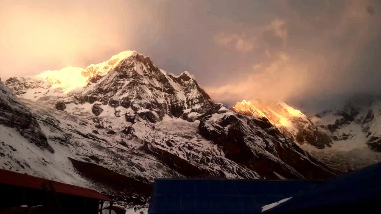
Ganesh Himal from the village of Helambu, Nepal · photo CC BY-SA 4.0 by Patlal Ghising on Wikipedia
I've never tired of maps, but mostly look at them online nowadays rather than opening my large, thick, world atlas book. I was a big fan of Microsoft's TerraServer project, which offered unprecedented satellite imagery of the entire globe in the late-1990s and early-2000s. TerraServer's success prompted many other companies to begin to offer similar tools, including Google Earth (which was disappointing and crude in the beginning, but has improved over time), and others. TerraServer was finally discontinued and assets were sold. TerraServer now redirects to a commercial website. I missed it quite a bit for several years until finally some alternatives came along that became as good, or better, than TerraServer once was.
There are also some good topographic map options online now that offer both flat views as well as "shaded relief" to show elevations. One of my favorites in this genre is Acme Mapper, likely the same one that Wile E. Coyote uses to stalk the Road Runner. 😁 Coupled with satellite imagery, it's a great way to explore our amazing earth!
One day about ten or fifteen years ago, I was poking around in maps of the Himalayan region of Nepal when I saw a mountain that resembled the outline of an elephant's head. Of course, it was an abstract, stylistic outline, as one might see while cloud-watching, but I thought was very cool, nonetheless! What shocked me was when I zoomed-into the map and read the name of the mountain of which the elephant-head was a part. It is called 𝐆𝐚𝐧𝐞𝐬𝐡 𝐈𝐈 ("Ganesh" followed by a Roman numeral 2). My mouth dropped open in amazement because I know the significance of that name.
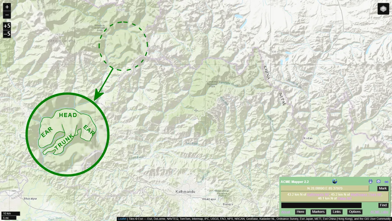
screenshot from Acme Mapper
Among the many religions that the Western world blindly calls "Hinduism" is an entity with the name Ganesha. Actually, if one reads the core Hindu scriptures, it is obvious that there is but One God. The many different "gods" that one sees in the religions of India are actually different manifestations of that One Deity. As I stated in one of my past posts:
"It is no different than how the scriptures of the Jews and Christians claim that their version of deity appeared as a "burning bush" to Moses, a disembodied hand writing on the wall in the story of Daniel, and manifested as a "still, small voice" to Elijah — again, One God with many manifestations."
Ganesha represents that aspect of The One who helps devotees deal with obstacles. He is usually depicted as having an elephant's head atop a humanoid body. As with most deities in the Hindu religions, Ganesha is depicted as having four arms as an illustration of power greater than what ordinary humans possess.
𝐆𝐚𝐧𝐞𝐬𝐡 𝐈𝐈 is one of the peaks in the Ganesh Himal, a sub-range within the greater Himalayan Mountains. Although not as tall as Mount Everest (8,848.86 m or 29,031.7 ft), the Ganesh Himal are still substantial mountains. The highest peak is 𝐆𝐚𝐧𝐞𝐬𝐡 𝐈 (also known as Yangra) at 7422 m (24,350 ft) followed by 𝐆𝐚𝐧𝐞𝐬𝐡 𝐈𝐈 at 7118 m (23,353 ft) in elevation.
It is this same 𝐆𝐚𝐧𝐞𝐬𝐡 𝐈𝐈 that has the appearance of an elephant's head on shaded relief maps, as shown above and below. However, centuries ago when the mountain range was named in honor of Ganesha, there was no aerial photography, and likely no reliable precursor to our modern-day topographic maps. So, how was the name of the range decided? The only clue I could find is this possibility:
"...the south face of Pabil (Ganesh IV) slightly resembles an elephant, with a ridge that is reminiscent of an elephant's trunk." [4]
In the following screenshot from PeakBagger.com, 𝐆𝐚𝐧𝐞𝐬𝐡 𝐈𝐕 (Pabil) can be seen marked by a red circle just southeast of the 𝐆𝐚𝐧𝐞𝐬𝐡 𝐈𝐈 massif. So, the part that resembles an elephant from the ground would be the dark area beneath the circle on the map. That might be how these mountains came to have Ganesha as their namesake.
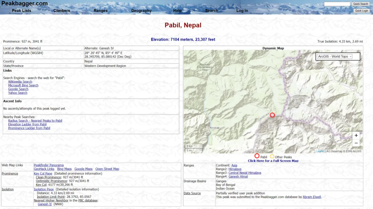
screenshot from PeakBagger

free clipart from zeevector.com · editing by me

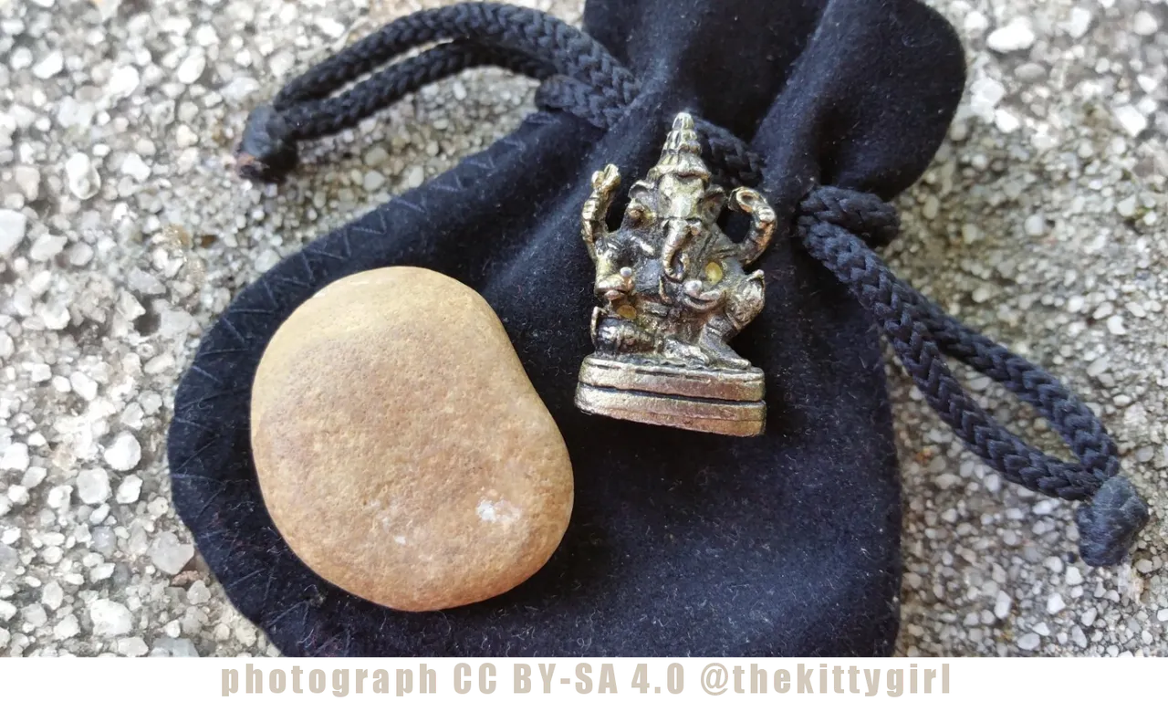
About thirteen years ago, my life crossed-paths with another woman for a couple of years and we had the opportunity of working together. At some point, she realized that our spiritual paths were remarkably close. She surprised me one day by reaching into her pocket and handing me this beautiful little statue of Ganesha. It was probably made in India since that's where she was born and lived until she migrated to the US with her British husband. It has had a special place in two different homes in which I've lived and it is most definitely a cherished item. I think of her often when I see it, although we've lost touch over the years. It is through Ganesha as well as through womanhood that we remain connected, through a sisterhood that transcends space and time.
Although the concept of Ganesha as an aspect of The One originated in the Shaivism religion, many of the other religions under the umbrella of "Hinduism" revere the concept of Ganesha, too. Even some adherents of Jainism and Buddhism also honor the aspect of Ganesha as well.[5] And, lest anyone accuse me of "cultural appropriation" here, rest assured that I am an adherent of one of the spiritual traditions that are relevant to this writing.
I have a little book titled Ganesh: Removing the Obstacles (ISBN: 1-886069-66-2) by James H. Bae about Ganesha (or "Ganesh" as some people spell it). In that little book, it says:
"Ganesh not only has the power to remove obstacles, but also to put them there in the first place so that we might learn a much-needed lesson or two. What may initially appear as an obstacle can ultimately be seen as a source of strength and a tool for self-exploration and understanding." [1]
 😊
😊SOURCES
1 Bae, James H., Ganesh: Removing the Obstacles (Novato: Mandala, 2002), p.26
2 Mapper.Acme.com
3 PeakBagger.com
4 Wikipedia: Ganesh Himal
5 Wikipedia: Ganesha


21-Sep-2021